Florida bracing for Hurricane Milton
Less than 2 weeks after Hurricane Helene devastated multiple southeastern U.S. states, another major hurricane is brewing in the Gulf of Mexico and is set for a collision with Florida in the coming days.
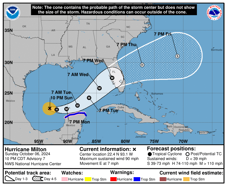
As of this afternoon (Sunday night eastern US time) Hurricane Milton is rapidly strengthening in the Gulf of Mexico and is expected to become a major hurricane in the next 24 hours. The national Hurricane Centre (NHC)'s latest track shows Milton tracking close to Mexico’s Yucatán Peninsula, before striking Florida late on Wednesday night eastern US time. A tropical storm watch is already in effect for Mexico’s Yucatán Peninsula.
In its latest advisory, the NHC is warning of “an increasing risk of life-threatening storm surge and damaging winds for portions of the west coast of the Florida Peninsula beginning early Wednesday” with related warnings and watches likely to be issued in the next 12-24 hours.
Image: Latest forecast track of Hurricane Milton as of Sunday night US time (Monday afternoon Australian time). Source: NHC
The storm comes less than 2 weeks after Hurricane Helene tore a path of destruction through the southeastern U.S, resulting in more than 200 deaths and cutting power to millions of residents across the southeast of the country. In possibly the only piece of good news, Milton is not expected to impact any other state in the same devastating way that Helene did a few weeks ago, meaning states such as North Carolina, which was particularly devastated from the effects of Helene, can continue their recovery efforts.
Even though there are still a few days until Milton makes landfall, there is already reasonable confidence that the system will cross not too far from Tampa. There are indications that Milton will make landfall as a category 4 major hurricane, with sustained winds of more than 130mph (209km/h) the equivalent of a category 5 tropical cyclone in Australia. This will leave devastating impacts no matter where it hits.
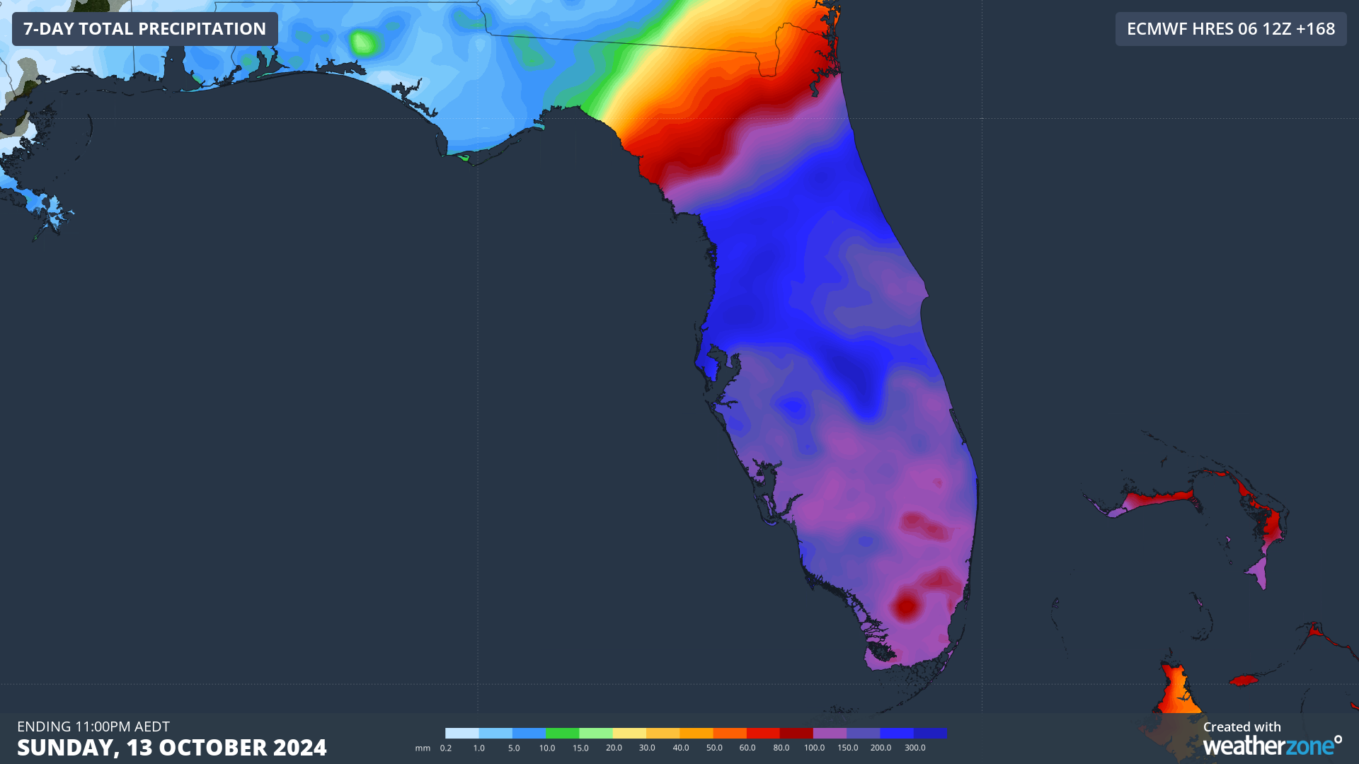
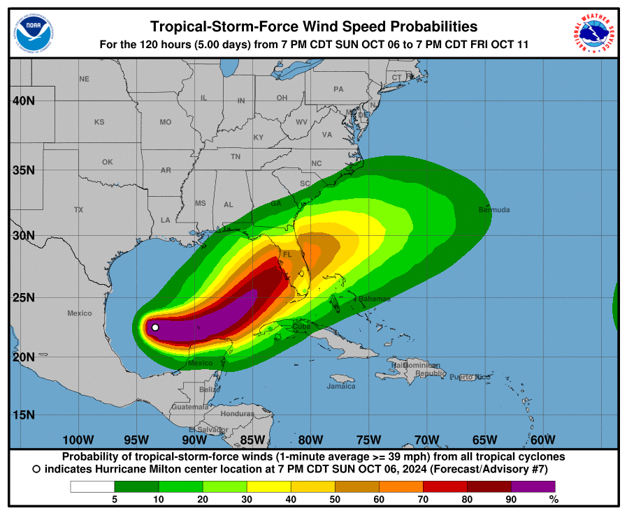
Image: probability of tropical storm force winds (exceeding 63km/h) in the next 5 days. Source: NHC
What could make conditions even more dangerous is a deep moisture stream affecting the Florida Peninsula, which is already bringing significant rainfall to the region. More than 100mm is expected for the area in the coming days, with Milton likely to add hundreds more as it crosses. Flood watches are already in effect for most of the Peninsula which will be exacerbated even further as Milton approaches later in the week.
Image: ECMWF forecast rainfall accumulated to next Sunday morning US time.
If you want to keep an eye on the latest warnings and updates, you can do so here. Furthermore, if you or anyone you know is in the area, make sure to take any safety precautions necessary up to, and including, evacuating if needed.


