Tropical Storm Hone Update for 7 a.m. on Saturday, August 24
(BIVN) – As of 5 a.m. on Saturday morning, Tropical Storm Hone was 260 miles southeast of Hilo, heading west at 15 mph.
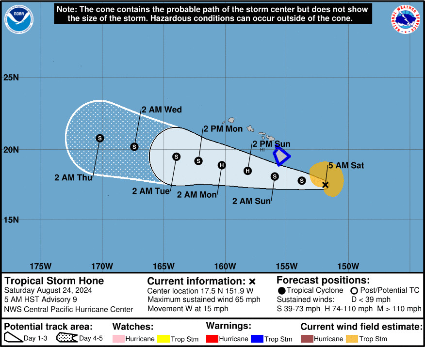
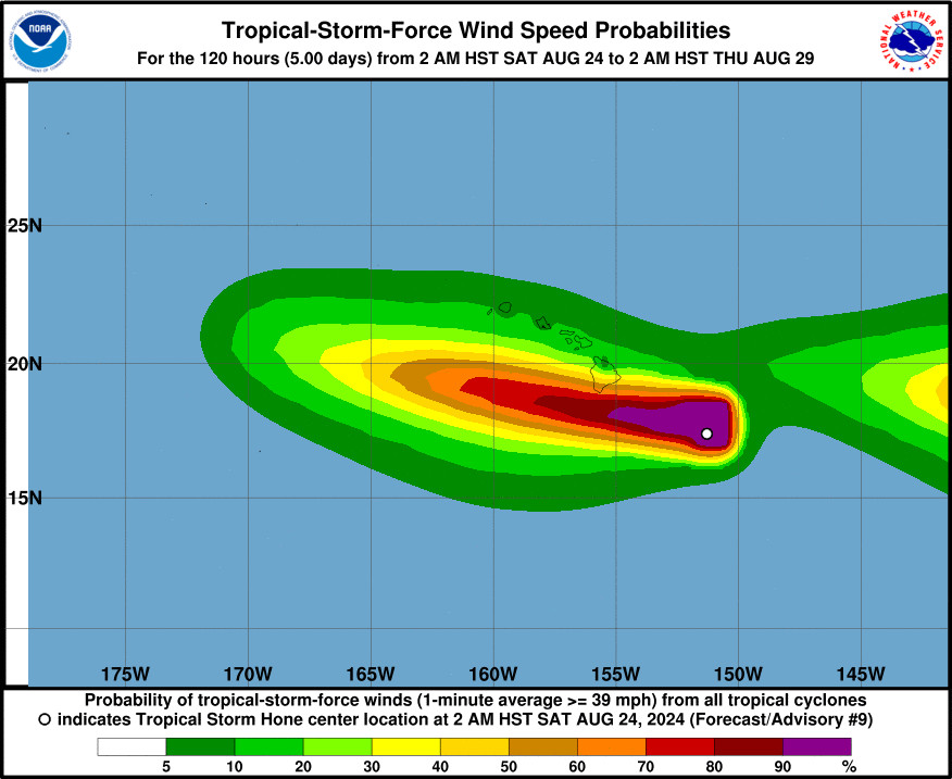
Hone is a strong tropical storm with maximum sustained winds near 65 mph, with higher gusts. Tropical-storm-force winds extend outward up to 115 miles from the center, and Hone is expected to strengthen into a hurricane by Sunday, as it passes southwest of Hawaiʻi island.
A Tropical Storm Warning remains in effect for the entire island of Hawaiʻi. The center of Hone is expected to pass near or south of the Big Island tonight into early Sunday, the Central Pacific Hurricane Center says.
There are multiple weather alerts in effect for the island of Hawaiʻi:
Tropical Storm Warning for the entire Big Island. Winds associated with Hone will increase over Big Island today and may become locally damaging by nightfall. Red Flag Warning for leeward areas until 6 p.m. due to a combination of strong winds, low relative humidity, and dry fuels that can contribute to extreme fire behavior. Flood Watch for the entire island of Hawaiʻi. Forecasters say the Hāmākua,Hilo, and Kaʻū Districts have the highest risk for flash flooding. Storm total rainfall estimates range from 5 to 10 inches, with locally higher amounts possible. High Surf Warning for east-facing shores of Hawaiʻi island. “Large and disorganized surf” will rapidly rise to 14 to 18 feet today through this evening, forecasters say.Preparations for Tropical Storm Hone should be completed by thismorning, officials say.
From this morning’s discussion by the National Weather Service:
Based on the current forecast track for Hone, strong and gusty winds associated with the system will begin to impact the Big Island later today, with widespread gusts up to 50 mph likely from this evening through early Sunday. The strongest gusts are expected around South Point/Ka Lae, as well as downslope from Mauna Kea, Mauna Loa, the Kohala Mountains, and the Humuula Saddle, which could see localized gusts as high as 60 mph. The Central Pacific Hurricane Center keeps the Tropical Storm Warning in effect for the Big Island. Now is the time to finalize your emergency plans and supplies and take the necessary actions to protect your family and secure your home or business.
Deep tropical moisture is beginning to surge into the windward slopes of the Big Island this morning and moisture levels are forecast to rise like the tide through tonight. This tropical moisture will then sweep westward to all islands tonight through Sunday, increasing the potential for heavy rainfall statewide. As rainbands associated with Tropical Storm Hone move into each island, heavy showers and thunderstorms will increase the threat for localized flash flooding. A Flood Watch remains in effect for the Big Island starting this afternoon. Shower coverage then expands down the island chain from Sunday into early next week as Hone passes to the south of the state. Storm total rainfall estimates for the Big Island will range from 5 to 10 inches with locally higher amounts possible. Smaller islands should see rainfall amounts from 2 to 4 inches. The higher amounts in these ranges will fall along windward mountain slopes of each island.


