El Nino watch: La Nina is finally over but more severe weather could ...
After three years of heavy rain and record floods across eastern states, La Nina is finally over — however, more extreme weather could be on the way.
The Bureau of Meteorology issued an El Nino watch on Tuesday, after long-range forecasts revealed a 50 per cent chance of the warmer, drier weather pattern occurring this year.
WATCH THE VIDEO ABOVE: El Nino watch has started as forecasts predict drier conditions.
Watch the latest news and stream for free on 7plus >>
“Conditions are now neutral — neither El Nino or La Nina — in the pacific ocean,” the Bureau said.
“There are some signs that El Nino could form later in the year.
“The long-range forecast for autumn shows drier and warmer than normal conditions are likely.”
The latter half of March could bring drier conditions, however northern Australia’s wet season will continue until April with a chance of tropical weather and heavy rain.
If you’d like to view this content, please adjust your .
To find out more about how we use cookies, please see our Cookie Guide.
What is the difference between El Nino and La Nina?According to the Bureau, El Nino and La Nina have the strongest influence on the climate changes for most of the country.
They are both part of a natural cycle called the El Nino-Southern Oscillation (ENSO).
La Nina occurs when ocean surface currents in the central and eastern tropical Pacific Ocean change and draw cooler deep water from below.
During La Nina there is usually increased rainfall across much of the country and cooler daytime temperatures.
Weather forecast map for Wednesday, March 15. Credit: BOMConversely, El Nino takes place when ocean surface temperatures become warmer than average. This means reduced rainfall, warmer temperatures, shifts in temperature extremes and an increased fire danger in southeast Australia.
The El Nino watch indicates a very different “high-risk severe weather season” is possible, according to Bureau meteorologist Sarah Scully.
“What it’s actually telling us is that the last three years of La Nina and the record-breaking rainfall for eastern Australia is over,” she said.
“An El Nino watch is that there’s a 50 per cent chance of an El Nino developing during 2023, so there’s still high uncertainty.
“We will keep a really close eye on it. What we do know is La Nina is over and those above-average rainfalls are finished.”
There have been 27 El Nino events since 1900.
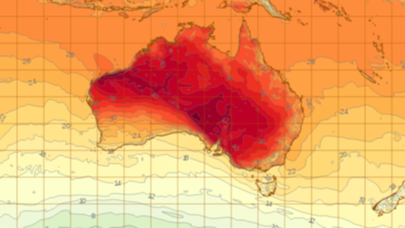
Three-day heatwave forecast for Wednesday, Thursday and Friday. Credit: BOMWarm temperatures expectedScully said a high-pressure system that has developed in the upper atmosphere is currently building heat over much of the country.
“We’ve got heat building over WA and inland Australia due to a high-pressure system that’s developed in the upper atmosphere,” she said.
“That really hot air mass is being dragged over southern and eastern parts of the country which is bringing a burst of summer-like conditions.”
While central, southern and eastern Australia will be impacted by the system from Thursday, the southern coast of WA and Tasmania will be affected by cold fronts Scully said.
“But in particular, NSW and southern Queensland and parts of inland Victoria will be seeing this hot burst continuing well into next week,” she said.
If you’d like to view this content, please adjust your .
To find out more about how we use cookies, please see our Cookie Guide.


